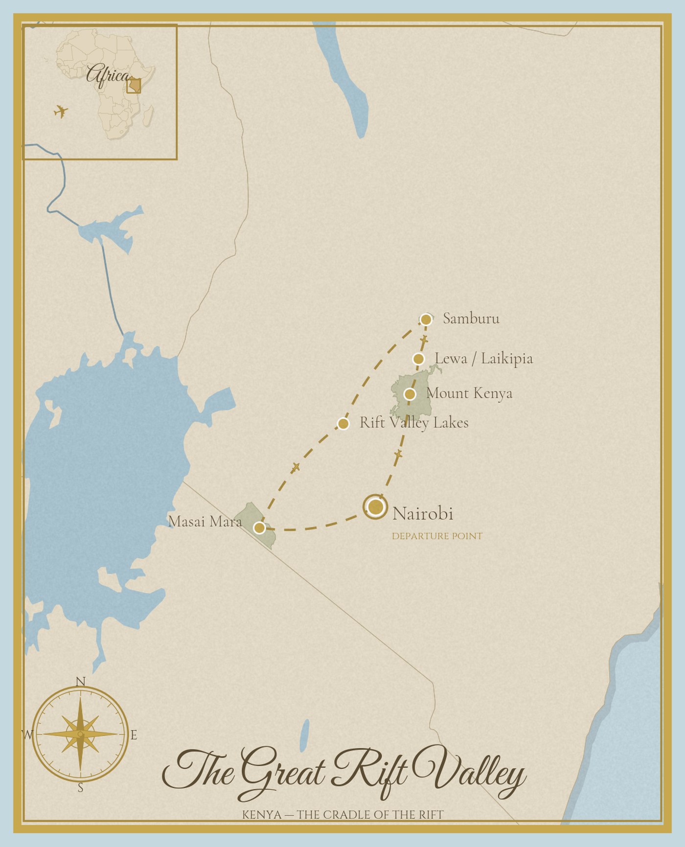
Ten days, five stations, two UNESCO World Heritage Sites — following the East African Rift from the Great Migration through the flamingo lakes to the equatorial glaciers of Mount Kenya.
The East African Rift is slowly splitting the continent in two. As it does, it creates everything this journey encounters: the grasslands of the Masai Mara, the alkaline lakes that turn pink with two million flamingos, the volcanic highlands of Samburu, the Laikipia Plateau where black rhino are guarded around the clock, and the equatorial glaciers of Mount Kenya — five ecological zones compressed into 3,000 vertical metres. One tectonic process, five landscapes, two UNESCO World Heritage Sites. The route that defined "Out of Africa," now reframed through the geology that made it possible.
| Days | Station | Nights | Heritage Highlight | |
|---|---|---|---|---|
| 1 – 2 | Masai Mara, Kenya Great Migration · Big Five · Maasai culture 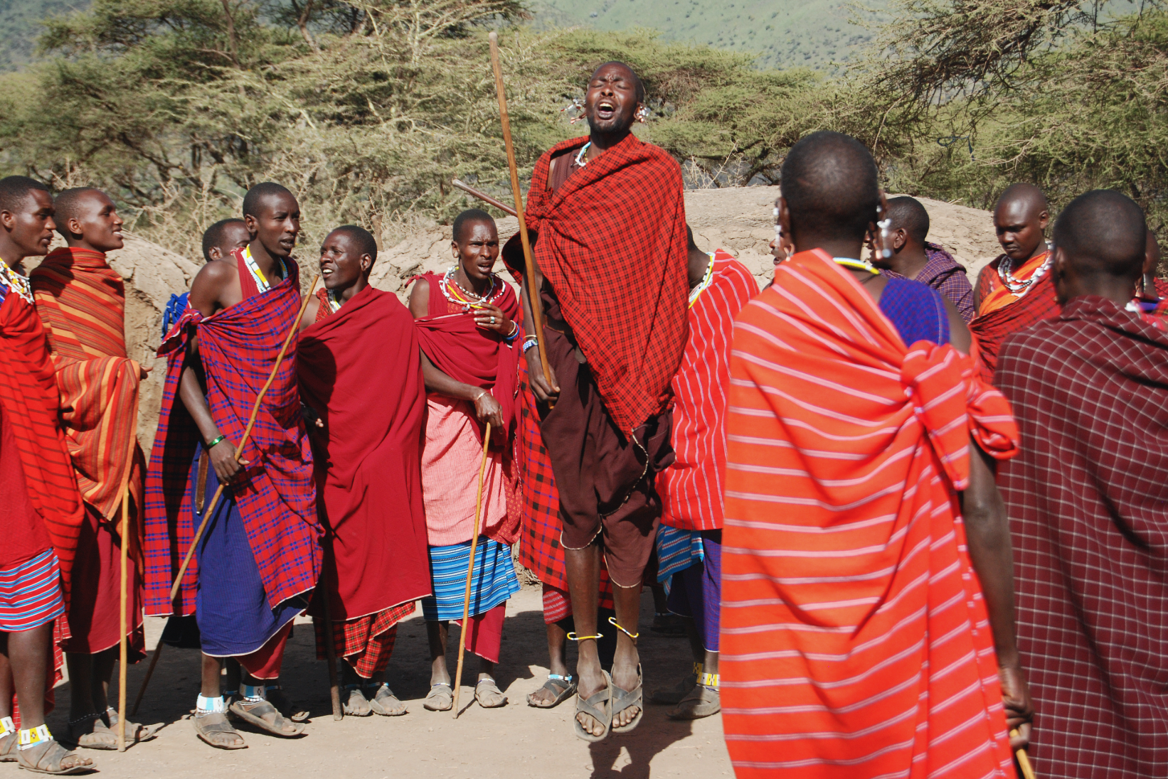 | 2 | Great Migration · Maasai pastoral heritage | ▼ |
The journey begins on the Mara — Kenya's most celebrated ecosystem, where the Great Migration brings 1.5 million wildebeest across the Mara River between July and October. A clifftop lodge above the Mara Triangle with full escarpment views. Morning and afternoon game drives, walking safari with Maasai guides, sundowner on the escarpment edge. The landscape that inspired Karen Blixen and defined the idea of the African safari. Great MigrationBig FiveMaasai VillageBush DinnerBalloon Safari | ||||
| 3 – 4 | Rift Valley Lakes, Kenya Two million flamingos · Alkaline lakes · Rift floor 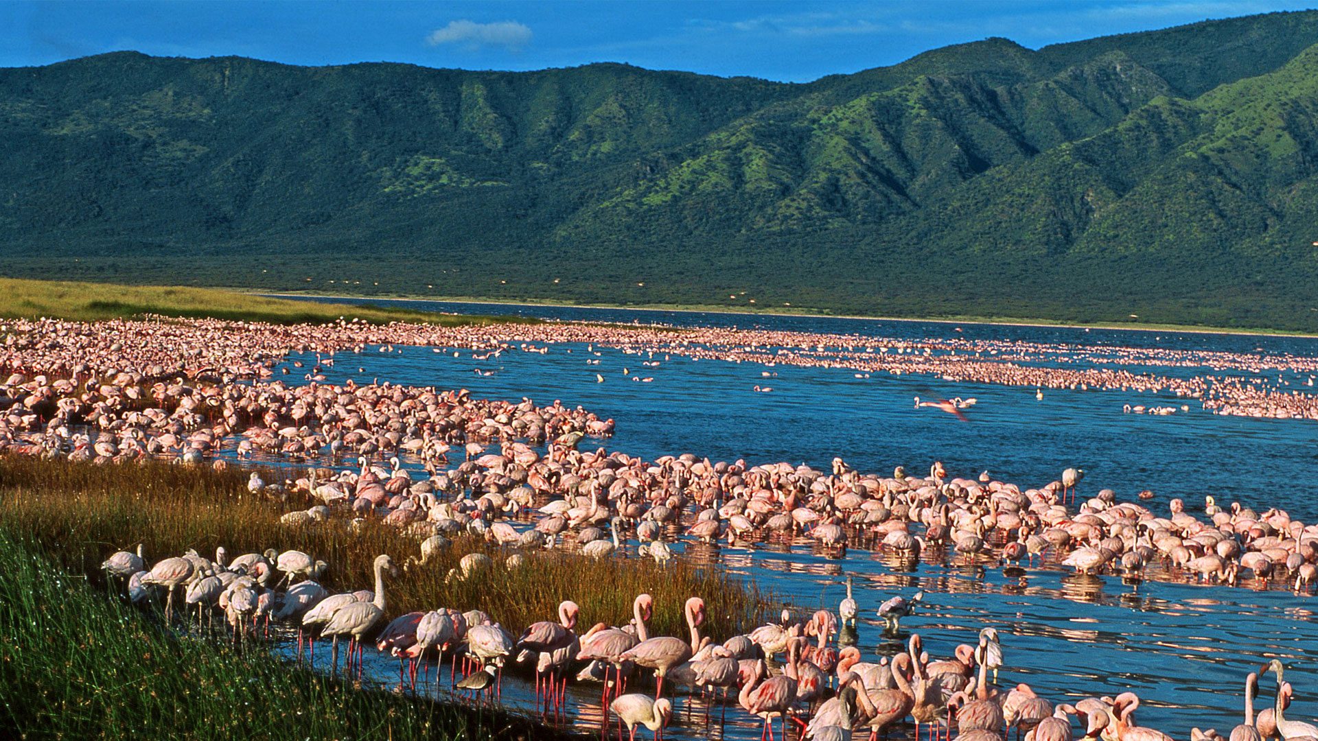 | 2 | Kenya Lake System (UNESCO) | ▼ |
The Rift dropped the valley floor between two fault lines. Volcanic minerals leaching into closed drainage systems created the alkaline chemistry that supports the world's largest flamingo concentrations — up to two million birds turning the lakeshore pink. Lakes Bogoria, Nakuru, and Elementaita form the UNESCO-inscribed Kenya Lake System. A lakeside lodge on the Rift floor, with boat safari on Lake Naivasha and flamingo viewing at Bogoria's geysers. Flamingos UNESCOLake BogoriaGeysersLake NaivashaCrescent Island Walk | ||||
| 5 – 6 | Samburu, Kenya Northern frontier · Grevy's zebra · Reticulated giraffe 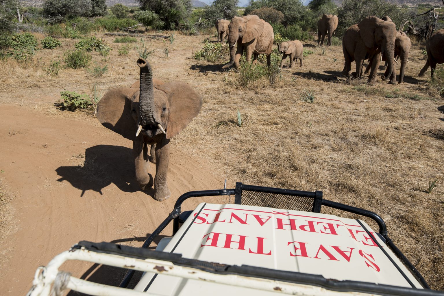 | 2 | Samburu Special Five · Desert ecology | ▼ |
North of the equator, the landscape shifts to semi-arid desert scrub along the Ewaso Ng'iro River. Samburu holds species found nowhere else on the route: Grevy's zebra, reticulated giraffe, Beisa oryx, gerenuk, and Somali ostrich — the "Samburu Special Five." The Samburu Elephant Project has tracked individual elephants for decades. A desert camp on the river, with Samburu warriors as guides — a pastoral culture as distinct from the Maasai as the landscape is from the Mara. Samburu Special FiveGrevy's ZebraElephant ResearchSamburu CultureNight Drive | ||||
| 7 – 8 | Laikipia Plateau, Kenya Rhino sanctuary · Community conservancy · Laikipia Plateau 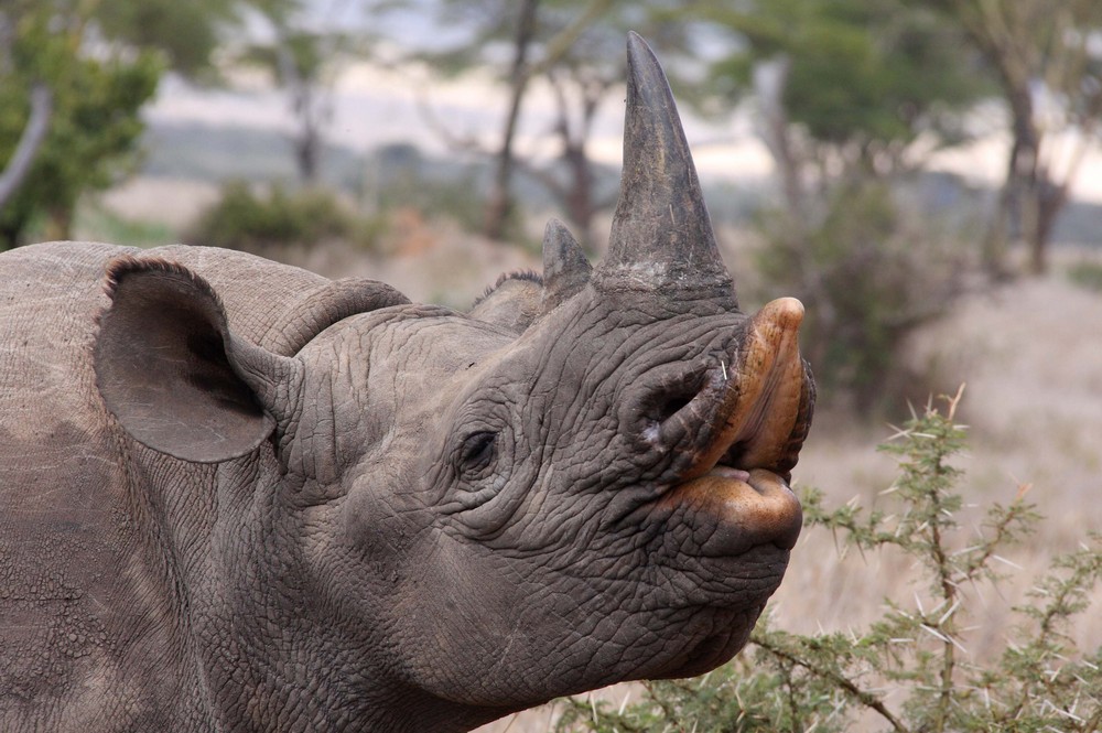 | 2 | Conservation frontier · Rhino sanctuary | ▼ |
The Laikipia Plateau holds Kenya's highest concentration of black rhino outside a national park — guarded around the clock by community conservancies that have made conservation an economic model, not just an ideal. A conservancy retreat where walking safari, horseback safari, and night drives are standard. The transition from Samburu's desert to Laikipia's highland plateau prepares the altitude for Mount Kenya ahead. Black RhinoWalking SafariHorseback SafariCommunity ConservancyNight Drive | ||||
| 9 | Mount Kenya, Kenya Equatorial glaciers · Five ecological zones · 5,199m 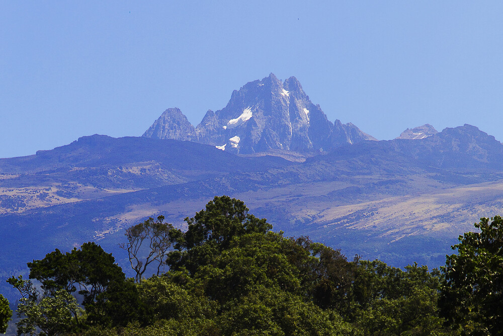 | 1 | Mount Kenya NP (UNESCO) | ▼ |
The volcanic product of the same tectonic stress that created the Rift Valley lakes. Africa's second-highest mountain — 5,199 metres — with equatorial glaciers retreating at accelerating pace and five ecological zones compressed into 3,000 vertical metres: rainforest, bamboo, hagenia, moorland, and ice. A mountain lodge at the forest edge with views of the peaks. The journey ends at the Rift's highest expression — the geological counterpoint to the flat lake basins where it began. Mount Kenya UNESCOForest WalkTrout FishingMountain BikingEquatorial Glaciers | ||||
| 10 | Departure — Nairobi | — | — | |
Click on a station to discover more
9 nights · 10 days — Two UNESCO World Heritage Sites visited
The Rift broke the land open. The break created a chain of alkaline lakes — Bogoria, Nakuru, and Elementaita — in closed drainage basins with no outlet to the sea. Volcanic minerals leaching into these basins produced the specific alkaline chemistry that feeds the cyanobacteria on which flamingos depend. Up to two million lesser flamingos concentrate here — the largest single-species avian gathering on Earth. The flamingos are not incidental: they are the ecological signature of a geological process that is splitting a continent in two.
The Rift's vertical expression. Mount Kenya is the volcanic product of the same tectonic stress that dropped the Rift floor and created the lakes. The mountain's equatorial glaciers — retreating at accelerating pace — and its five ecological zones, from montane rainforest at 2,000 metres to ice at 5,199, compress the continent's climate into a single vertical cross-section. The lakes are the Rift's horizontal heritage; the mountain is its vertical counterpart. One geological process, two World Heritage expressions.
The journey begins on the Mara — where the Great Migration brings 1.5 million wildebeest across the river between July and October. A clifftop lodge above the Mara Triangle with full escarpment views. The landscape that inspired Karen Blixen and defined the idea of the African safari. Walking safari with Maasai guides, balloon safari at dawn, sundowner on the escarpment edge.
The Rift's horizontal signature. Volcanic minerals in closed alkaline basins feed the cyanobacteria on which flamingos depend — up to two million turning the lakeshore pink. A lakeside lodge on the Rift floor at Lake Naivasha. Day excursion to Lake Bogoria's geysers and flamingo shore. Crescent Island walking safari among giraffe, zebra and hippo. The flamingos are the ecological proof of a geological process splitting the continent.
North of the equator, the landscape shifts to semi-arid desert scrub along the Ewaso Ng'iro River. The "Samburu Special Five" — Grevy's zebra, reticulated giraffe, Beisa oryx, gerenuk, and Somali ostrich — are found nowhere else on the route. The Samburu Elephant Project has tracked individual elephants by name for decades. A desert camp on the river, with Samburu warriors as guides.
Kenya's highest concentration of black rhino outside a national park — guarded by community conservancies that have turned conservation into an economic model. Walking safari, horseback safari, and night drives are standard on the plateau. The altitude rises steadily toward Mount Kenya, visible on the eastern horizon. The transition from Samburu's desert to Laikipia's highland prepares the landscape for the mountain ahead.
The Rift's vertical counterpart. Africa's second-highest mountain — 5,199 metres — with equatorial glaciers retreating at accelerating pace and five ecological zones compressed into 3,000 vertical metres. A mountain lodge at the forest edge, with views of the peaks. Forest walk among giant camphor trees and black-and-white colobus. Trout fishing in mountain streams. The journey ends where the Rift reaches its highest expression — from flat pink lakes to ice at the equator.
Transfer to Jomo Kenyatta International — or connect to the Great African Waters southbound via the Serengeti.
| Transfer | Airstrip → Lodge | Distance | Flight Time |
|---|---|---|---|
| Nairobi (Wilson) → Masai Mara | On-site airstrip — 10 min | ~250 km | 1 hr |
| Masai Mara → Rift Valley (Naivasha) | Road transfer — 20 min | ~200 km | 50 min |
| Naivasha → Samburu | On-site airstrip — 10 min | ~250 km | 1 hr |
| Samburu → Laikipia | On-site airstrip — 10 min | ~100 km | 30 min |
| Laikipia → Mount Kenya | Nanyuki — 30 min road | ~80 km | 25 min |
| Mount Kenya → Nairobi | — | ~180 km | Road — 3 hrs |
All inter-station flights operate as domestic Kenya charters — zero cross-border flights. Cessna Grand Caravan or equivalent light aircraft via Safarilink or private charter. All airstrips are established safari strips with daily service.
This journey follows a single geological idea. The East African Rift broke the land open. The break created the grasslands of the Mara, the flamingo lakes, the desert frontier of Samburu, the rhino plateau of Laikipia, and the equatorial glaciers of Mount Kenya. Every station on the route is a product of the same tectonic force — seen from a different altitude and in a different ecology.
The route that defined "Out of Africa" — now understood through the geology that made it possible.
Founder & Director, Southern Cross Experiences (Pty) Ltd.
Chairperson, African Sustainable Tourism Organization
Masai Mara to Mount Kenya — ten days following the East African Rift through five landscapes and two UNESCO World Heritage Sites.
Plan Your Safari